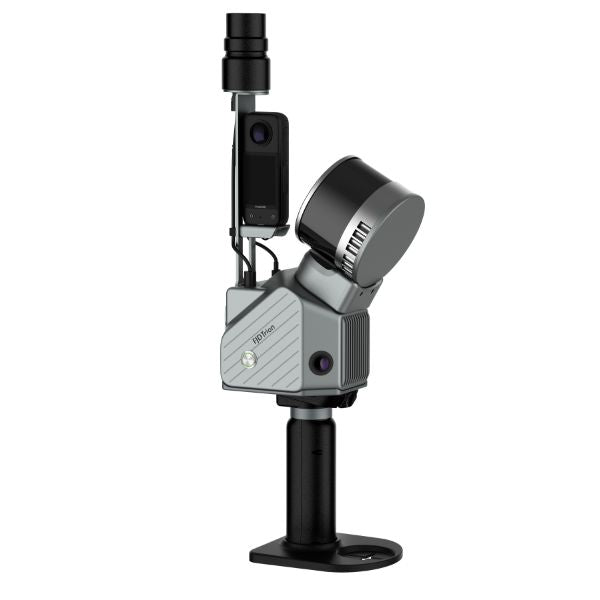
Phone: +1 888 850 6533
Mon - Fri: 9 am - 5 pm (MT)
Phone: +1 888 850 6533
Mon - Fri: 9 am - 5 pm (MT)
Phone: +1 888 850 6533
Mon - Fri: 9 am - 5 pm (MT)
Phone: +1 888 850 6533
Mon - Fri: 9 am - 5 pm (MT)
The FJD Trion S2 revolutionizes 3D LiDAR scanning with state-of-the-art technology. Featuring high-speed data acquisition at 640,000 points per second, advanced SLAM algorithms, and real-time visualization, the Trion S2 is designed for precision mapping in both indoor and outdoor environments.
Integrate camera, IMU, and RTK modules into a compact form of 2kg, allowing for versatile surveying projects.
Embed two 12MP cameras to generate high-resolution images with advanced Visual-Inertial Odometry (VIO) and SLAM algorithms, delivering accurate results even in complex environments with fewer feature points.
With an integrated RTK module, directly get georeferenced point clouds on the go. RTK & PPK support ensure accurate data collection in dense tree canopies and other signal-challenging areas. Plus, with over 8000 coordinate systems, no fear of tedious coordinate conversions anymore!
Assess structural integrity, plan spaces, and identify areas in need of repair or renovation. Reduce uncertainty in investment decisions with insights from a rich spatial dataset.
Leverage point cloud data to enhance disaster preparedness and recovery plans. Quickly record evidence and crime or accident scenes for immediate and accurate forensic documentation.
Make more informed decisions on your projects from blueprint to QA/QC with building surveys, scan to CAD & BIM, as-built documentation, floor plans, and stockpile volumes.
Accurately map and analyze terrain features with high-resolution point cloud data. Streamline land development projects, environmental studies, and infrastructure planning.
Improve safety and efficiency in mining operations. Use point cloud data to assess mining environments, and improve underground mapping accuracy.
Manage and monitor tree inventory with a quick walk in the forest. Measure crowns, analyze breast diameter, and tree height using precise point cloud data.